|
Card
The identified area of interest (that includes the monumental zone of Ortigara and the Cima Caldiera) undoubtedly constitutes one of the area of highest historical interest among the entire highland, theatre of one of the bloodiest battles of the First World War: Action K better known as the Battle of Ortigara (June 1917).
The remains of the imposing defensive works set in place by both armies (trenches, stations in caves, observation posts) and the complex system of roads, muleteers and logistics centers, still manifest today great fascination and a strong evocative power.
From Mount Forno to the northern mountainside of Mount Ortigata that overhang above the beneath Valsugana, the most northern segment of the so called winterstellung unwinds, or rather, the resistance line on which the Austro-Hungarian troops fell back after the conclusion of the Strafexpedition.
It is a complex system of trenches dug-out in the living rock and still as of today mostly perfectly preserved, strengthened by cave positions among which the Mecenseffy works should be highlighted which dominates the Agnella valley, the "nest" of five machineguns obtained from within the so called "caverna Biancardi" ("Biancardi cavern") located along the steep western slope that from altitude 2101 comes down towards the beneath pass of Agnella, the Thurmau tunnel of Mount Chiesa and the stations obtained beneath the mountain tops of Forno connected one another by an extensive system of tunnels. In the immediate rear of the front line, the remains of the barracks can still be observed, as well as the command centers, the cableway stations and the aqueducts, the battery stations and the burial grounds (in particular the small and striking cemetery of Campigoletti) that are disseminated along the western slope of the mountainous relief, in the rock gorges, within the numerous dolina (the so called Dolina degli Sloveni [Slovenians'Dolina] on Mount Chiesa is to be considered exemplifying due to its particular size) and along the main communication routes.
The Italian lines can be found opposing the Austro-Hungarian positions which, from Lozze, climb up north to the peak of Caldiera and to the front of the promontory of Campanaro. The system of trenches, track ways, caverns and barracks appear here to be even more impressive both for their extension and for their specific complexity as well as for the audacity of some of the works. Among these we have the barrack complex of Pozzo della Scala, the castling road that from Lozze square goes up to the eastern slope of Caldiera up to the saddle found immediately beneath the peak and the cave observatory, set-up on various levels and built in the summer of 1917 by the 19th comp. of the 5 regiment miners beneath the foresummit of Caldiera.
The area of Ortigara, also thanks to the cleaning-up activities and the sign placing of the most significant works accomplished by the army and by the volunteers of the ANA in the seventies and at the start of the nineties, is surely the most known battle ground of the highlands and probably with Pasubio and Grappa, of the entire Italian front, destinations which every year brings thousands of visitors.
The entire area is crossed, besides the numerous roads and war muleteers still in fairly good conditions, also by the Sentiero della Pace (Path of Peace) and by some tourist pathways indicated by CAI. The overall good accessibility (already foreseen by the completion of the asphalting of the access road to the Lozze square that from Gallio outcrops to the valley of Campomulo) and the environmental context, of certain high value together with the historical importance of the events tied to these grounds and to the overall state of conservation of the manufactured works present, undoubtedly make of this area, the natural and most complete "open air museum" of the Great War of the entire Vicentine front.
Mount Ortigara
Austro-Hungarian defensive system made-up by a main in-rock trench and by the parallel elements with annexes positions excavated in rock and cave shelters located along the eastern slope of the Ortigara;
Mecenseffy defensive complex with barrier blocks in the below Agnella valley (Stunzpunkt Florio and the Meceseffy flankenwerke);
Complex of barracks and Austro-Hungarian cavern shelters on the western slope of Ortigara;
Observatory and cave machinegun positions "Galleria Biancardi" (Biancardi Gallery);
Austro-Hungarian stronghold with machinegun positions and cavern artillery altitude 2003;
In cavern Austro-Hungarian medication post to the north-west at altitude 2101 with annexed cemetery;
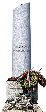
In valley cemetery of Agnellizza;
|
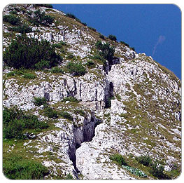 - Trench remains
|
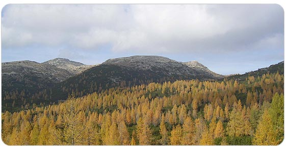
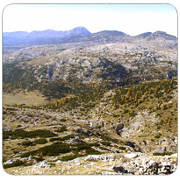 - View from Mount Ortigara
|
  
|