|
Monte Pasubio
"The Museum road"
|
|
 |
|
 |
|
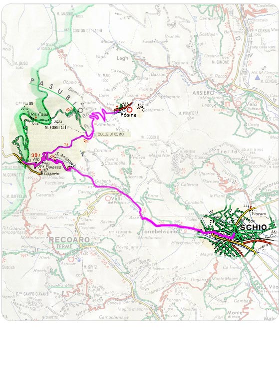
From Schio: take the road for Rovereto, once you have passed the built-up area of Valli del Pasubio after a series of hair-pin bends and after leaving behind on the left hand side (approx. 500 m. from the road) the fortified complex of Fort Maso, you will reach the area of Ponte Verde (m.902) where you will turn towards the hill of Xomo-Posina. The road continues with various bends through the woods and climbs up along the slopes of Mount Forni Alti. Military remains and paths can be seen all around. Once you reach Colle Xomo, on the left hand side the road climbs up until the area of Bocchetta Campiglia (with a wide parking lot), from where by taking the road "Strada delle 52 Galleria" or the Scarubbi road (close-off to traffic) you will reach Porte del Pasubio (m. 1928). From the Ponte Verde area and still following the direction for Rovereto, continue until Pian delle Fugazze in Trentine territory from where, once you have parked the car in the wide parking lot, the road "Strada degli Eroi" will take you to the summit of the massif in about 3 hours.
From Posina: from the built-up area of Posina in the direction of Colle Xomo, a winding road begins which climbs alongside the mountain woods and leads underneath the perimeter of Campiglia, passing by malga Xomo. Continue on the right hand side of the hill towards Bocchetta Campiglia. From there take road "Strada delle 52 Gallerie" or road Scarubbi (close-off to traffic) towards Porte del Pasubio.
From Rovereto: from the center of Rovereto in the direction of Schio, the road leads into a winding and very suggestive pathway, after passing through Vallarsa it leads into the area of Pian delle Fugazze (with a wide parking lot) from where the road "strada degli Eroi" will lead towards the mountain peaks.
|
|
 |
|
 |
|